Smoked Out: When Wildfire Haze Turns VMC into IMC
New for 2026: I’ve put this theory to work and created an interactive Visibility Map.
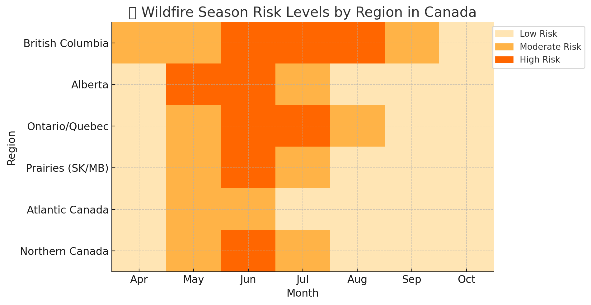
Wildfire season in Canada typically runs from May to September. Over the past 20 years of flying, it’s become clear to me that wildfire seasons in Canada have grown not just longer—but more intense. I’m not alone in that view: Natural Resources Canada and multiple peer-reviewed studies agree that 2023 was the worst fire season in Canadian history, with over 15 million hectares burned—more than double the previous record. The likely culprits? Earlier snowmelt, prolonged drought, and rising temperatures—all driven by climate change.
Flight planning in smoky conditions is not something that is taught in ground school. So based on the past 5 years of flying Plane Jane in and around smoke. I give you a guide on how to plan your VFR flight when smoky conditions are forecast. But first, the fundamentals:
What Are Visual Meteorological Conditions?
VMC in Canada is defined as:
| Airspace Type | Condition | Flight Visibility | Cloud Clearance |
|---|---|---|---|
| Controlled Airspace | Cruise (any time) | ≥ 3 SM | ≥ 500 ft below, 1 mile horizontally |
| Aircraft must maintain visual reference to the surface | |||
| Uncontrolled Airspace | Day (below 1,000 ft AGL) | ≥ 2 SM | Clear of cloud |
| Day (above 1,000 ft AGL) | ≥ 1 SM | ≥ 500 ft below, 2,000 ft horizontally | |
| Night (any altitude) | ≥ 3 SM | ≥ 500 ft below, 2,000 ft horizontally | |
Source: CAR 602.114–117 | All visibility values are in statute miles (SM)
Flight visibility is of our utmost concern as smoke primarily affects visibility at the surface and aloft. For the purposes of this exercise we are not going take special VFR (SVFR) rules into consideration.
What Is Smoke?
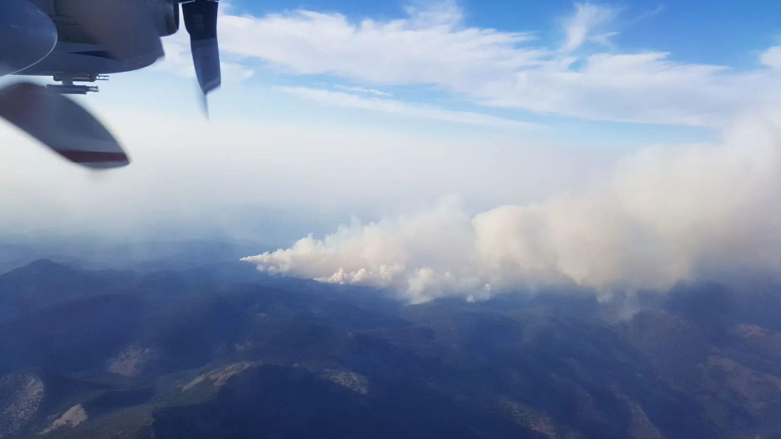
In aviation meteorology, smoke refers to a suspension of fine solid particles in the air, primarily resulting from incomplete combustion of organic material such as trees, brush, and grasses. During wildfire events, these particles—mostly particles less than 2.5 microns in size —can remain suspended in the atmosphere for hours to days, often traveling hundreds or even thousands of kilometers from their source.
Unlike fog or mist, which are composed of water droplets (and somewhat transparent), smoke consists of dry particulate matter that can significantly reduce horizontal visibility and obscure terrain or landmarks critical for VFR flight. The extent of visibility degradation depends on particle density, size, composition, and atmospheric conditions like humidity and wind.
Let Me Introduce You To PM2.5
PM2.5 stands for particulate matter smaller than 2.5 microns in diameter—about 30 times smaller than the width of a human hair. These tiny particles are a key component of wildfire smoke and are small enough to stay suspended in the atmosphere and infiltrate cockpit ventilation systems.
What makes PM2.5 especially relevant to VFR flying is its ability to scatter and absorb light, which reduces visibility both horizontally and vertically. Unlike larger particles (like dust or PM10), PM2.5 can travel farther, rise to cruising altitudes, and linger longer, making it a persistent hazard even far from active fire zones.
How Particulates Reduce Visibility
PM2.5, soot, dust, sulfates, and organic matter (called: aerosols) affect visibility in two main ways:
- Light Scattering: Aerosols diffuse sunlight, creating a hazy or milky sky. The more particles in the air, the more light is scattered, which diminishes the clarity of distant objects—essential for visual navigation.
- Light Absorption: Some aerosols, like black carbon or smoke from burning organic material, absorb light, further reducing contrast and making terrain, traffic, and horizons harder to see.
Together, these effects can degrade visual meteorological conditions (VMC) even if skies appear “clear” from the ground.
Making The Situation Worse: Humidity
A higher relative humidity (smaller temperature/dewpoint spread) causes something called hygroscopic growth. Hygroscopic growth is the process by which tiny particles in the air—like PM2.5—absorb water vapor when humidity is high. As they absorb moisture, they grow in size and become even more effective at scattering light, which reduces visibility.
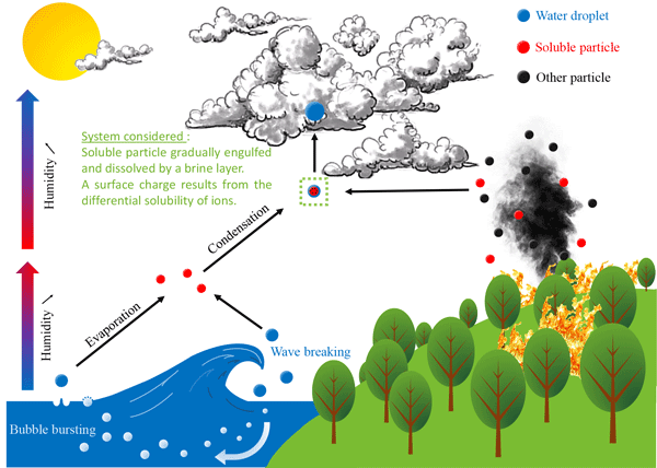
This effect is common in high-humidity summer regions like Southern Ontario, where visibility might appear fine on the ground—yet degrade rapidly aloft. Studies have shown that visibility can drop by more than 50% when hygroscopic growth is active—even without a significant change in PM2.5 concentration.
Putting It All Together: Blake’s Visibility Risk Score.
So, the following factors mainly affect visibility both at the surface and aloft:
- Density of PM2.5 aerosols (measured in μg/m³)
- Temperature / dewpoint spread
Our challenge is going to be predicting visibility aloft since every online resource I’ve been able to find only displays forecasted PM2.5 levels at the surface. As we all know: smoke rises. Therefore levels at altitude can be dramatically different than at the surface. Upper air mixing, temperature inversions, and wind shear can all affect visibility in smoky conditions. So as a rule of thumb, if the surface PM2.5 forecast indicates:
- <35 µg/m³ → likely OK for VFR (unless inversions or poor vertical mixing of air occurs)
- 35–80 µg/m³ → marginal VFR risk
- 80+ µg/m³ → possible IFR conditions due to smoke/haze
And if the temperature / dewpoint spread is:
- 5+°C → Generally good VMC
- 3–5°C → Possibly marginal VFR
- < 3°C → Significant VMC degradation
Putting these two variables together, I’ve created a Risk Matrix showing how combinations of PM2.5 levels and temperature/dewpoint spread affect expected VFR conditions at the surface.
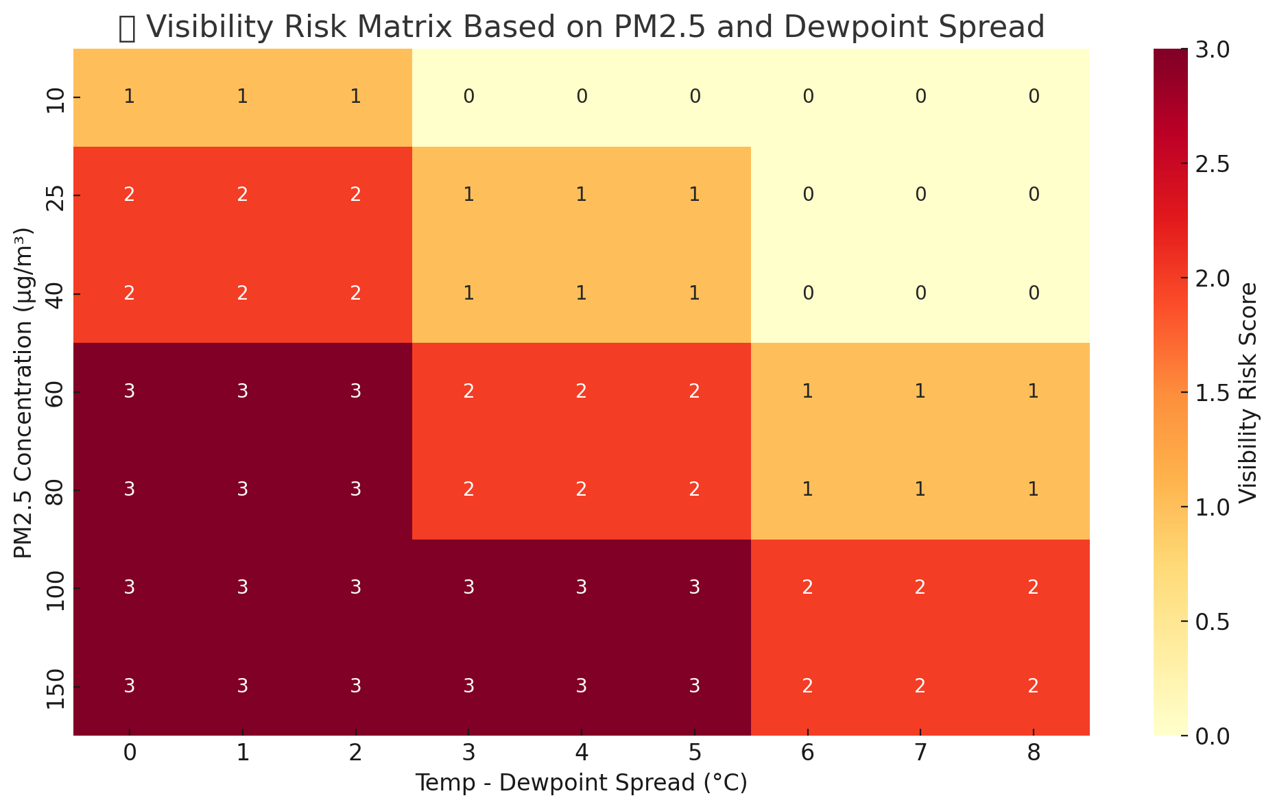
- 0 (Good VMC) – Clear skies and good visibility
- 1 (Some Haze) – Mild reduction in visibility
- 2 (Marginal VFR) – Risk of dipping below VFR minima
- 3 (Likely IFR) – Smoke + moisture could push visibility into instrument-only territory
I’ll leave it up to you and your risk tolerance on when you’ll decide to scrub a VFR flight (for example with a visibility risk score of 2 vs. 1).
A Real World Example
On July 26, 2021, a Bombardier Challenger 605 crashed during a circle-to-land approach at Truckee-Tahoe Airport. The NTSB speculated that reduced visibility from wildfire smoke may have obscured the runway, contributing to the crew’s inability to establish visual contact. Despite these conditions, METAR reports did not indicate significant visibility reductions due to smoke.
Automated weather reporting stations don’t factor in PM2.5 levels and dewpoint spread in their visibility reports. So extra caution is to be used when flight planning with automated weather stations.
So with that in mind, let’s plan our flight. Let’s say you are departing your airport which is reporting: Temperature: 17°C, Dewpoint: 15°C, and a visibility of 6sm. You fire up Windy on the PM2.5 layer, selecting your departure time and location and see that the PM2.5 levels are forecasted to be 55 µg/m³ at the surface.
Going back to my Risk Matrix, we find 55 on the Y-axis, and 2C on the X-axis (the dewpoint spread). We see that the risk score is “3” or a high chance that visibility aloft will be IMC. In other words: Even with a METAR reporting 6 SM, inflight visibility could degrade quickly—especially near valleys or inversion layers where smoke concentrates.
Conclusion
We haven’t talked about the other risks of flying in smoky conditions. Such as cockpit air quality, engine performance, and escape strategies. However, my philosophy and risk tolerance is not to get your self in these situations in the first place. Especially inadvertent flight into IMC, trust me, It happened to me once in smoke.
I hope that this post and especially the Risk Matrix will be another tool in your flight planning tool belt to make more informed pilot decisions when it comes to flight planning during forest fire season.
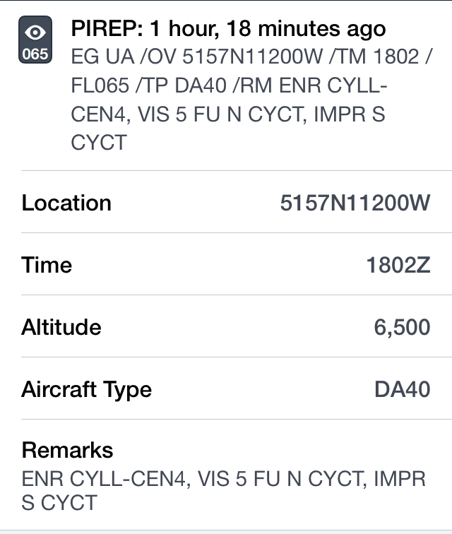
However, if you do find yourself flying in smoky conditions please file a pirep to let other pilots know what the actual conditions are aloft.