Circuits!
I started doing circuits today. Fun stuff. I don’t think that I will ever get bored of them. I have a lot to write about but I’m going to make this one short (and update you about other stuff in another entry).
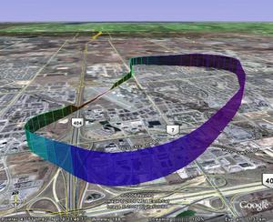
 I booked two lessons today. On the second lesson, I decided to bring along my GPS for the ride so that I could plot my track (and elevation) on a map for later study. Got to the airport and the weather was questionable but we decided to go up anyways. I figured it would be a good experience to see what its like to fly in low visibility.
I wish there is an archive of METARs and SPECIs online. So that I can go back to the time of the flight to see what the posted visibility is. If anyone knows of one, please let me know. In any case.. it was bad. At one point in the circuit, we couldn’t see the airport (on the base leg). According to my measurements in Google earth, the visibility was less than 1.5SM. So what we ended up doing, was follow woodbine south until we saw the runway, then corrected.
To better illustrate, you can download the track for Google Earth or you can see a Google Maps version. One thing to note though is that the elevation/altitude data from the GPS is pretty inaccurate. It doesn’t have a pressure altimeter in it so it calculates its height based on triangulation.
Oh boy, did I ever think circuits were fun when I started them as well. I actually made a blog entry called “Circuits are fun!” as well.
The amusement factor begins to fade quickly though after 40 or so of them, trust me. By the time you gain your solo clearance away from the airport you will be glad to be done with them. (grin)
Actually, it’s the pressure altimeter that’s pretty inaccurate. Even when you have the correct altimeter setting, it can be hundreds of feet off (thousands, at cruise altitudes) depending on air temperature, pressure gradiants, etc. It doesn’t matter for aviation, since everyone sees the same errors (unless, of course, you’re trying to clear a mountain ridge in IMS).
GPSs aren’t usually too bad for altitude, and handheld GPSs with WAAS (like the Garmin 196 and up) are extremely accurate.
Yes.. you are absolutely right. What I meant by inaccurate was that a pressure altimeter would have been more “sensitive” to changes than the GPS altimeter.
If my GPS sample rate was smaller (say every 1 instead of every 20 seconds or so) then the climbs and descends would probably appear more smooth and less like I’m falling out of the sky.
This GPS is also not “aviation” certified in anyway. It’s just a hand held eTrex Venture.