GIS Experts: Elevation Data North of 60°N?
I’m looking for raster elevation data for Canada for a project I’m working on. I’ve been using NASAs SRTM 3 data in the meantime.
The problem? It doesn’t cover latitudes above 60° I took a look at the CDED data from Geobase, however the time it takes me to query that data for elevation data is way too long. I don’t know why, since the resolution is the same as that of the SRTM data. Perhaps its the format it’s stored in?
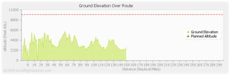
This problem can be visualized in the below graph. A flight from Bella Coola, BC to Fort Ware, BC only has elevation data for the first 160nm of the flight or so. Then, no data is available because of the lack of SRTM 3 data.

A part of me wants to take the CDED data and convert it from ASCII DEM to SRTM HGT format. WIll that improve performance?
So how does this apply to aviation? These data sources are used for TWAS and GWPS. Take a look at these two papers from Jeppeson:
A worldwide SRTM terrain database suitable for aviation use.
World-Wide Precision Airport Mapping Databases for Aviation Applications