Find Me Spot!
 I got a satellite personal tracker for Christmas called Spot. The idea behind the device it threefold:
1. Use it to track your progress (whether it be flying, hiking, sailing, etc…) and display it in near real time on the internet for your “team” to keep an eye on you.
2. Use it to call for help from your “team”.
3. Use it in an emergency to initiate search and rescue efforts.
The system works the same way satellite phones do. The satellite system it uses is called Globalstar and a coverage map is available online. The data that it is transmitting is GPS co-ordinates along with your unit number to Spot’s servers.
This information is then disseminated in either three ways:
1. Its stored in your account on Spots website.
2. It can be emailed to any email address
3. It can be text messaged to a phone.
Only the “check in” and “help” features allow you to notify someone that you’re ok or need help. There is no notification that a tracking session has started.
I did a quick test of the system last night and it works great. Pressing the help button yielded a text message within 3 minutes of initiating the request. You can customize what the “im ok” and “help” messages say.
This is an excellent complementary device to your 406Mhz ELT as it can be used to give you an exact location (by way of GPS co-ordinates) to the emergency responders. However it should not be used to replace it as it is not automatically activated in a crash and is not certified by Transport Canada.
One of the interesting features Spot offers is called “GEOS Search & Rescue Benefit”. For $8 a year you can get an added layer of security that is offered by the GEOS Alliance. It “provides up to $100,000 USD of additional search and rescue resources, including helicopter extraction around the world and reimbursement benefits – underwritten by Lloyd’s of London – for any emergency service expenses incurred”. For you hardcores out there that will literally be in the middle of nowhere.
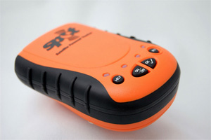
The unit is rugged and water proof. It feels sturdy and well built. It’s bright orange so its easy for you to see, and a LED flashes every 3 seconds when its on for finding it in the dark.
There are, however, some things that I think could be improved on:
There is no way to create a “read only” account for your team members to use to track your progress. The progress tracking is recorded in the same account as your devices, which includes your billing information and such.
When tracking is turned on, you manually have to refresh the page each time and select the points you want to display on the map. The map doesn’t automatically refresh.
No API to include tracking data into your own applications. There are ways around this, but it would be nice to have a supported method of being able to include the tracking data (or even export it as a csv) into your own applications.
When tracking mode is on, you position is recorded every 10 minutes. It would be great if this value could be adjusted either way (to say every 5 minutes, or every hour).
I have yet to try this baby in the air, but I suspect it will work flawlessly.