I went on a flight on Sunday to practice some radio navigation work.
It didn’t go so well…
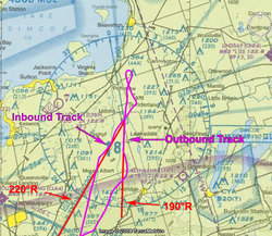
It was bumpy as hell, but I decided to see if I could track the Simcoe (YSO) VOR inbound on the 220° radial. Didn’t happen. I got confused with the to/from flag. I was actually thinking that I had the right radial dialed in, but instead I had the reciprocal. Whoops! Flying towards the needle to intercept actually had the opposite effect. Damn that to/from flag!
At least I was able to identify station passage when I entered the cone of confusion (I love that term!).
I did a one eighty and tried to track the 190° radial outbound with a little more success.
To get back to the airport, I dialed in the Buttonville NDB (KZ) and had better success. Again, I was able to identify station passage with the ADF needle swung around.
I brought my GPS along for the ride with the idea of plotting my track on VNC chart to review my flying. I scoured the net and found no such service.
gpsvisualizer.com allows you to overlay your gps data on numerous types of maps (and google earth) but no aeronautical charts. You can’t do it at skyvector.com, runwayfinder.com, flyagogo.net, or gearsdown.com. Why do people always re-invent the wheel. All these sites pretty much do the exact same thing (my favorite du jour is runwayfinder.com).
Can someone please allow me to upload my GPS data and overlay it over aeronautical charts?
(Yes, I could do it my self by scanning in a chart, rectifying it, then overlaying the data using some tool – i’m lazy)
Update: I did find a way to overlay the charts in google earth, which sufficed.


