
A Little Project…
There are a lot of online flight planning tools out there. However, none of them (that I’ve found) focus on Canadian planning.
That said, a friend and I have been working on getting something set up (we don’t have a name for it yet) for Canadian pilots.
One of the features we plan on releasing is an interactive map where you can click your departure, waypoints, and arrival locations on an “aeronautical” aware google map.
It’s unfortunate that NavCanada doesn’t provide geotiff versions of their maps, like the FAA does.
Here is a screen shot of what we’ve come up with so far:
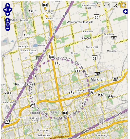
This is a view of Buttonvilles’ Control Zone with a few nearby airways. Eventually you will be able to control how cluttered the map is by selectively displaying navaids, airspace, airways, and airports.
I am having some trouble with storing more complex airspace definitions, for example CYA512(P). Any PostGIS experts out there that can help me, please drop me a line by leaving a comment or clicking on the “contact” link at the top of the page.
Once you pick your route, information such as METAR/TAF and FDs are automatically fetched and used to produce all your necessary flight planning numbers.
If there are any features you would like to have in this web application, please let me know!
Blake,
On my most recent flight, CYKZ vfr CYTZ, CYTZ vfr CYOS, returning to CYKZ, I would have loved to be able to plot my course, airway or VOR and have all of the information returned to me on a map I could print out and use in conjunction with Nav Canada maps.
Would you be able to have the appropriate radio frequencies of aerodromes enroute available for printing with the map? This could be similar to the CAA Trip Tik. Perhaps include a section for filling out a flight plan form which prompts you for information and gives you a drop down menu to choose the appropriate response? How about a printable aerodrome map for each of the aerodromes in the flight plan and also of aeordromes nearby the flight path?
Now here is my copywrited suggestion for a name:… “For Canadian Pilots”. Feel free to use it if you wish.
… Al.
YKZ Class D below 2500, oops!
This idea is amazing Blake. No doubt it would help pilots who are unfamiliar with the complex Toronto airspace.
Thanks for the comments!
This isn’t going to be a replacement for your current charts and CFS. So I’m hesitant to provide information that can be found elsewhere in official documents.
This will immensely increase situational awareness for low-time pilots. By combining lots of information from many difference sources in one easy to use application you can (potentially) eliminate many distractions, such as unfolding huge maps, and flipping through the CFS. (although as someone already pointed out, you still need to bring them with you) This all increases ‘heads-up’ time, allowing the pilot to listen and watch more effectively.
Its a good project that you’re trying to take up. Just because I know, there’s a software called Flight Wizard, and it does have all Canadian airports and routes and all. I’ve used it at time, and found it to be more of a nuisance as opposed to actually being helpful..
I don’t know how your project is finally gonna work like, but I think sticking to map and pencil is so much better.
Good luck with the project anyway,
Cheers!
Yes, I use Flight Wizard as well. I actually like it better than map and pencil only because it saves me a lot of time.
I can whip up a quick flight log and plan in less than 5 minutes. While using map and paper will take me at least 30.
If anything, you can use it to validate your map and pencil calculations.