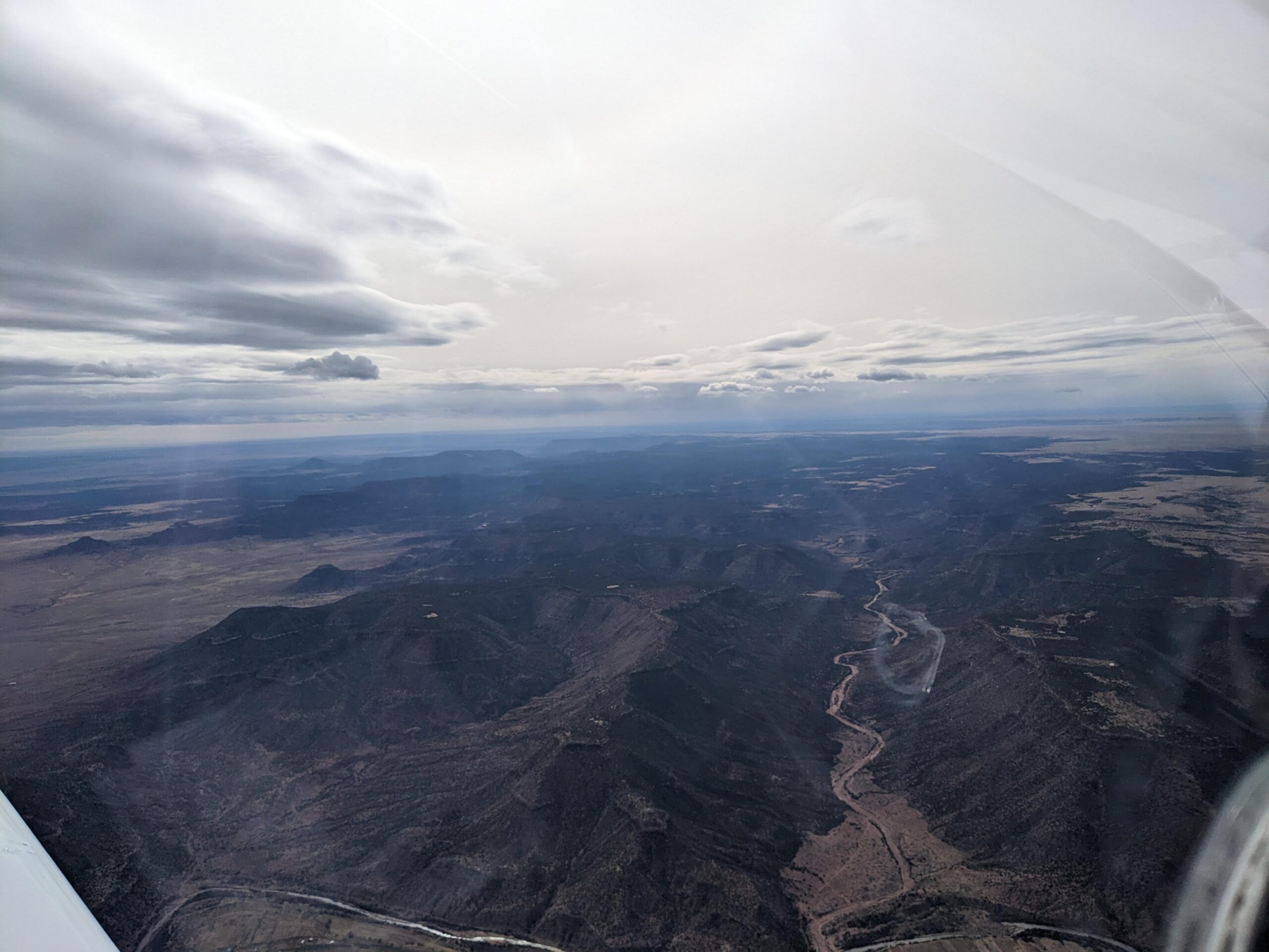
Crossing The Southern Rockies At 11,000′
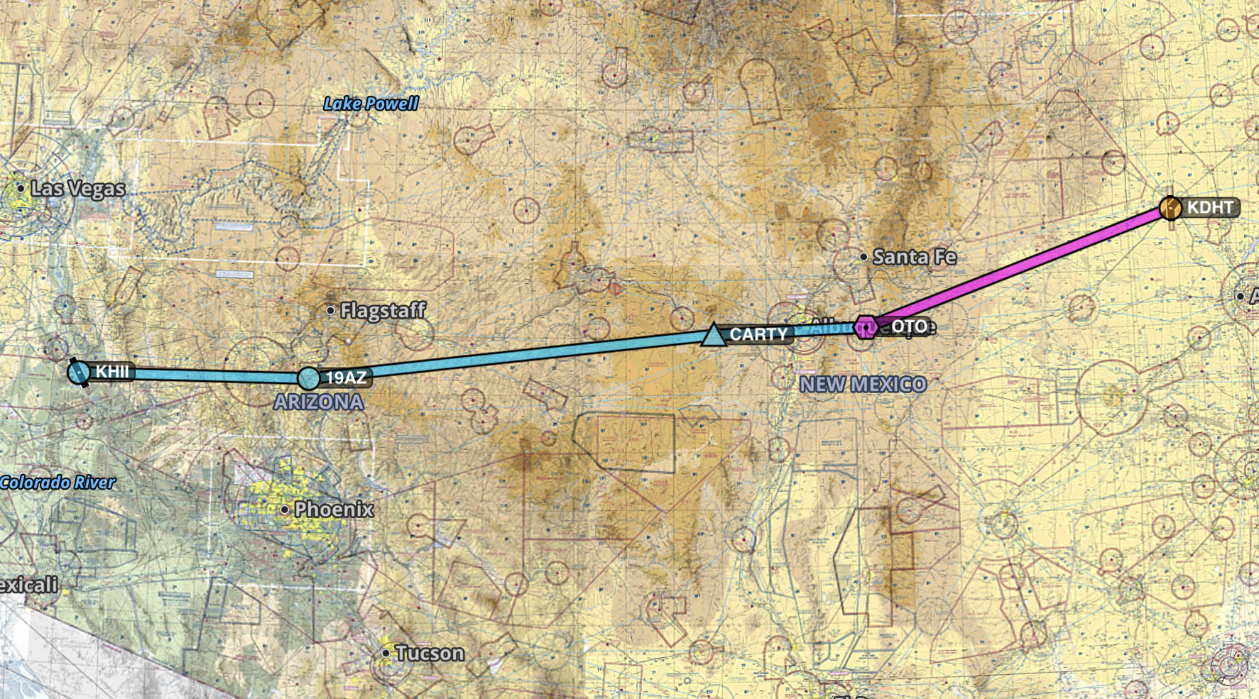
Making my way westward towards Lake Havasu, Nevada (KHII), I decide to stop for lunch in Dalhart, TX (KDHT). The next leg of my flight will involve scrutinizing the route on a full stomach.
With my iPad and ForeFlight open, I’m interrupted by a fellow pilot inquiring if that’s my airplane on the ramp and where I’m going. I explained to him that this is my first time crossing the The Rocky Mountains and I show him my route.
He has flown over this particular part of the mountain range many times and graciously gives me tips and corrections to my original route.
Flying High and Hypoxia
One of the biggest considerations when flying in mountainous terrain is dealing with the lack of oxygen in unpressurized aircraft. The rules for flying in the USA with regards to having to use supplemental oxygen are a little different than in Canada.
| Canada (CAR 605.32 (1)) | United States (14 CFR § 91.211) |
| Flights Below 10,000′: No supplemental O2 required Flights Above 10,000′: O2 required if flight is longer than 30 min Flights Above 13,000′: O2 is required for full duration of flight. | Flights Below 12,500′: No supplemental O2 required Flights Above 12,500′: O2 required if flight is longer than 30 min Flights Above 14,000′: O2 required for full duration of flight. |
(Interesting side note: In Canada every occupant needs to use O2 above 13,000′, not just flight crew. As with in the USA only if the flight is above 15,000′ does every occupant need to use O2).
Considering that my route of flight will be over terrain that is at least 11,000′ MSL (and not having O2 on board) being able to take advantage of the less restrictive rules in the USA will make things a little easier for flight planning.
Terrain Clearance
I personally like to keep at least 2000′ above ground level when flying on cross country flights (weather and winds permitting). In case of an engine failure or other emergency, this will give me at least 2 min of “air time” before landing. Not ideal, but does give me enough time to make the necessary radio calls and pick a landing spot.
Considering I’m flying westbound on this leg. I’m limited to even number altitudes: 8,500′, 10,500′, 12,500′, etc..

A direct flight from Dalhart to across the mountain range wouldn’t work. The terrain just north of Santa Fe is just too high considering the service ceiling for Plane Jane is only 14,000′. Not to mention the fact that I don’t have O2 to use on board.
Revised Routing
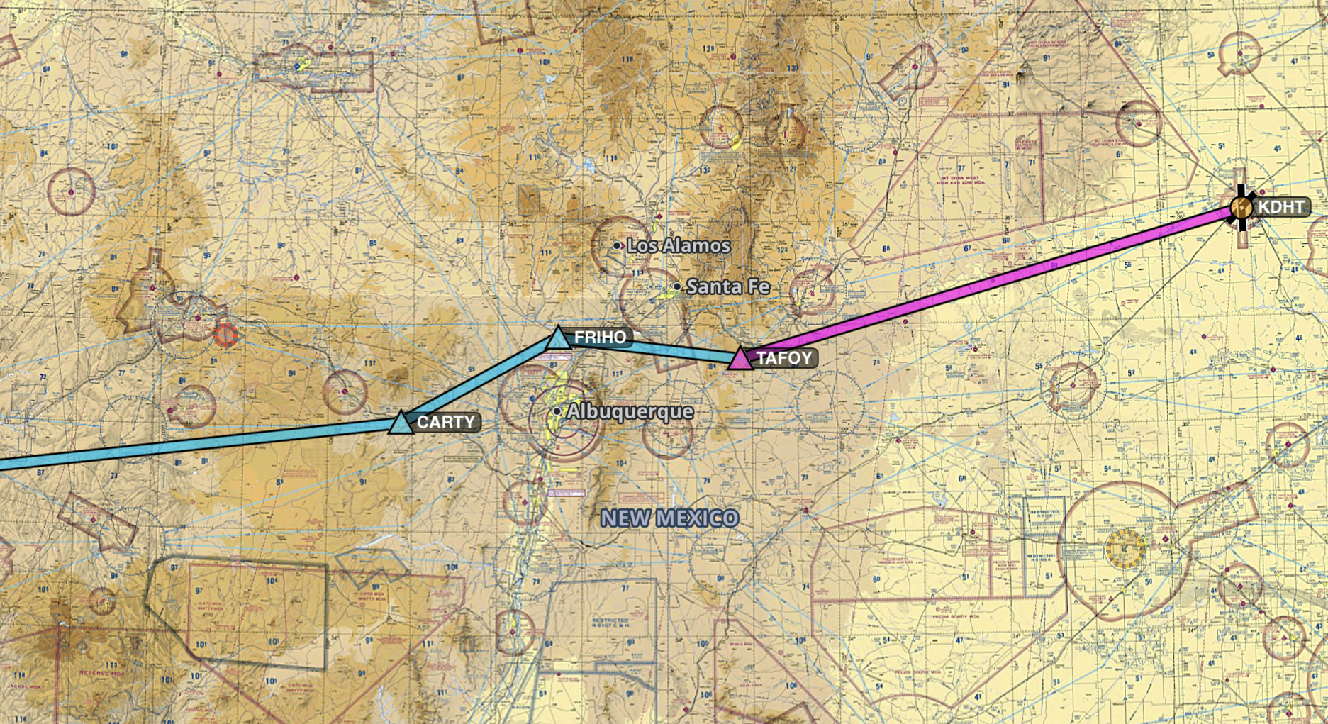
A quick swing to the south to the OTO VOR would avoid the high terrain near Santa Fe. Then a slight southern turn to the CARTY fix to avoid Mount Taylor seemed like the perfect solution.
I show this routing to my new pilot friend at the restaurant and he seemed a little concerned.
“You’re going to have to deal with some turbulence and possible mountain wave issues with the Sandia Mountains near Albuquerque. It’s pretty windy/bumpy out there today”.
He suggested that I pass north of the Sandias and offered the FRIHO fix as a usable waypoint.
“Are you flying VFR or IFR?” he asked.
I replied sheepishly: “VFR, planning a cruise altitude of 10,500 feet”.
“Ahh! There were a few clouds at around 11,000′ and I encountered some icing on my descent. Also a few patches of precipitation here and there along that route.”
Not words I wanted to hear. He continued:
“If things look harry en route, I recommend bugging out at KLVS before making the crossing and waiting for better weather tomorrow”.
I thanked him for the advice and he wished me good luck. The first challenge begins!
Full Stomach and Full Fuel
I hop in Plane Jane confident that I have local knowledge on making this mountainous flight a success. I depart Dalhart with 6 hours of fuel and head westbound to my first fix: TAFOY.
In cruise I decide to take a look at the weather along my route thanks to ForeFlight and Sirius XM. Although the turbulence forecast is only valid for altitudes above 18,000′ I decided to take a peek anyway:

Considering I’m almost 10,000 lower I’m not too concerned about the patches of moderate turbulence. It’s been a smooth ride so far since I departed about 30 minutes ago. I load up the weather radar map overlay:

Damn. There is mixed precipitation directly over my route of flight. Not to mention the two PIREPS (Pilot Reports) of icing at 10,000 and 12,500 feet (the blue icons on the map).
Taking the advice of a fellow pilot I met an hour ago, I decided to divert to fake Las Vegas (KLVS). This was not a planned stop, so I didn’t have arrangements for a hotel. Nor, do I even know if there is anyway for me to get from the airport to the town. Challenge two begins…