Radio Navigation with MS Flight Sim
After reading over the chapter on radio navigation, I decided to try it out – using Microsoft Flight Simulator 2004.
I hopped in my Cessna 172, and departed Buttonville on runway 33. I climbed up to 4,000 feet and turned on the autopilot and told it to hold this altitude. First item on the list, understand how the ADF works. The ADF is a simple device that points you in the direction of the radio beacon. A simple arrow on a dial. Just turn the airplane until the arrow points straight up, now you’re headed towards the NDB. 
I tuned the radio to 248KHz (which was the closest NDB from Buttonville). I was surprised to hear the morse code identifier! Flight Sim rocks!
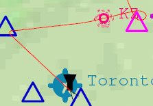
I turned the airplane into the direction until the arrow pointed straight up. I flew and flew until magically the needle swung around 180 degrees! I passed the NDB. Task one complete. The little pink icon (circle, not triangle) on the map on the leftis the NDB. You can see when I started homing in on it as my track veered to the right (east).
The next task was to use a VOR. VORs are used by everyone from private pilots to commercial airliners. They are the key to navigating the skys. I was a little confused as to how these work, since they are a little more complex than the simple NDBs. A VOR allows you to intercept it at a specific heading, called a radial. There is an indicator that tells you if you are left or right of the VOR. The idea is that you just keep the indicator centered and you will intercept the VOR at that radial.
 I tuned my nav radio to 117.35MHz, the Simcoe VOR. Then I selected which radial I wanted to intercept. And flew towards the VOR keeping the marker centered. The closer you get to the VOR the harder it is to keep the needle centered. What I ended up doing was fly past the VOR then select a radial that was in the opposite direction I was going (in this case 240°) just so that I can exaggerate my track. So I started turning the aircraft until the needle was centered, then kept on flying. Once the to/from flag flipped I knew that I was on the other side of the VOR. I took a look at my heading indicator, and sure enough it showed 240°! Awesome!
I saved my entire flight in this PDF. When I decided to head north to fly past the VOR, I took the “long way” (as you can see by the little loop in the track just east of the NDB).