Where’s That Landmark?
I originally was going to go on a cross country flight on Sunday… but decided against it in favour of some practice instead.
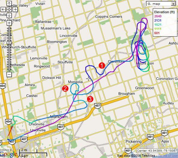
I headed out the Claremont training area to practice some forced approaches. This area is better than the north (cooks bay/Keswick) because it has more fields to choose from (and it’s not close to Greenbank airport).
Everything was going dandy until I decided to head back to the airport. There are a set of train tracks that run right through Claremont and go through Markham. I normally follow the tracks back to Markham, pick up the Markham water tower , then head back to the airport.
As I was following the tracks back I saw a town that I thought was Markham (Marker 1) and decided to turn towards it. After a while I consulted the map and discovered it was Stouffville so altered my course back towards Markham. I intercepted the tracks and started following them south west again.
I still couldn’t find the water tower so I decided to start circling (Marker 2) to see if I can find it. By this point I was at 2000′ to ensure that I was under Pearsons class C. The last thing I wanted to do was bust through into controlled airspace.
It only took me one revolution before I heard on the radio a plane call up Buttonville tower saying that they were over the Markham water tower. I spotted them about a mile and a half to my right and decided to follow them in (Marker 3). About 10 seconds later, I saw the water tower.
My problem wasn’t that I was lost… Technically I knew where I was. The problem was that I couldn’t’ find where one of the reporting points was in order to let Buttonville know where I was. If worst comes to worst I could have asked for a VDF steer.
How would you have handled this situation? Leave a comment.
I’d call the tower and ask for a “simulated” DF steer.
Tune in the nearest nav aid and use that to determine your position. Or if all else fails, own up and confess to ATC.
-dr
yeah.. a df steer is a possibility..
I knew where the airport was and I knew where I was I just didn’t know where my reporting point was.
I guess I could have just said “7 miles west of the airport”? But then I’m sure tower would just say “report over someplace” and I woudln’t know how to get there.
you don’t have to worry about that reporting point any more. The Markham Water Tower has been removed (as of Nov.16/2011)
John. Thanks for the update!
If not referring to GPS, I would tune a couple local VORs and quickly triangulate.
how did you generate that map of your route?
I had a GPS in the aircraft to record my track. I then used gpsvisualizer.com to put the track on a google map.
Yes, I was actually flying last week and was looking for the Markham Water tower and cannot locate it.. And I was confused and saying to myself “Where the —- is the water tower”!??) So, instead of reporting ‘over Markham water tower’ I just say “6.3 Miles East to the field” (I got a DME) :)